
Historic District Expansion
To see if the Town will vote to expand the Historic District by including properties, starting at the Chilmark/West Tisbury Town Line located on the Massachusetts State Highway (South Road/Vineyard Haven Road) to the West Tisbury Cemetery; Music Street to Panhandle Road; Massachusetts State Highway (Edgartown Road) to the parcel of land located on the western side of Daniel's Way; Old County Road (Southern end) to Dumont Drive. Properties are described as Assessors:
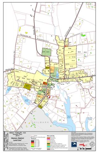
To See map larger click Here
| Map | Lot |
|---|---|
| 25 | 15 |
| 25 | 16 |
| 26 | 2 |
| 26 | 4 |
| 26 | 7 |
| 26 | 8 |
| 26 | 9 |
| 26 | 10 |
| 26 | 12.1 |
| 31 | 1 |
| 31 | 2 |
| 31 | 3 |
| 31 | 4 |
| 31 | 5 |
| 31 | 6 |
| 31 | 7 |
| 31 | 8 |
| 31 | 10 |
| 31 | 11 |
| 31 | 12 |
| 31 | 13 |
| 31 | 14 |
| 31 | 15 |
| 31 | 16 |
| 31 | 17 |
| 31 | 18 |
| 31 | 19 |
| 31 | 20 |
| 31 | 21 |
| 31 | 23 |
| 31 | 25 |
| 31 | 26 |
| 31 | 27 |
| 31 | 28 |
| 31 | 29 |
| 31 | 31 |
| Map | Lot |
|---|---|
| 31 | 41 |
| 31 | 42 |
| 31 | 43.1 |
| 31 | 55.1 |
| 31 | 55.2 |
| 31 | 57 |
| 31 | 114 |
| 31 | 115 |
| 32 | 120 |
| 32 | 11 |
| 32 | 23 |
| 32 | 24 |
| 32 | 25 |
| 32 | 25.2 |
| 32 | 25.3 |
| 32 | 26 |
| 32 | 27 |
| 32 | 28 |
| 32 | 29 |
| 32 | 36 |
| 32 | 37 |
| 32 | 38 |
| 32 | 39 |
| 32 | 40 |
| 32 | 41 |
| 32 | 42 |
| 32 | 43 |
| 32 | 44 |
| 32 | 45 |
| 32 | 49 |
| 32 | 50 |
| 32 | 53 |
| 32 | 54 |
| 32 | 56 |
| Map Lot | Lot |
|---|---|
| 32 | 57 |
| 32 | 60 |
| 32 | 62 |
| 32 | 67 |
| 32 | 68 |
| 32 | 69 |
| 32 | 70 |
| 32 | 70.1 |
| 32 | 70.2 |
| 32 | 70.3 |
| 32 | 71 |
| 32 | 72 |
| 32 | 73 |
| 32 | 89 |
| 32 | 90 |
| 32 | 91 |
| 32 | 92 |
| 32 | 93 |
| 32 | 94 |
| 32 | 97 |
| 32 | 98 |
| 32 | 101.1 |
| 32 | 103 |
| 32 | 104 |
| 32 | 105 |
| 32 | 111 |
| 32 | 113 |
| 32 | 119 |
| 32 | 120 |
| 32 | 122 |
| 32 | 124 |
| 32 | 127 |
| 32 | 128 |
| 32 | 131 |